RED Scientific are pleased to announce that we have been added to KTN’s UK Space Sector Landscape Map, along with over 1000 other organisations from the sector.
Developed in collaboration with the UK Space Agency and with support from key stakeholders, the Knowledge Transfer Network (KTN) has developed an interactive landscape map, which is set to become a main point of reference for the UK Space Sector – outlining the universities, companies, funding bodies and networks that work in it.
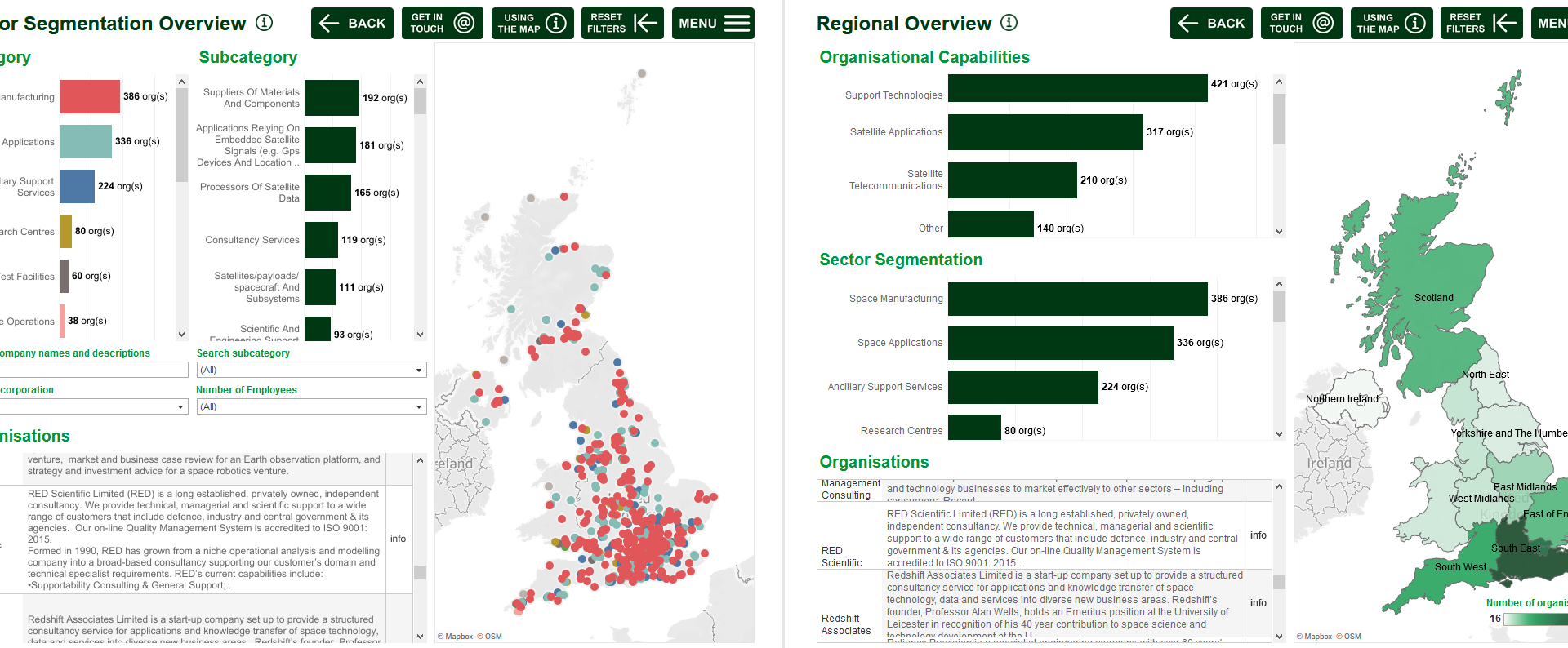
The map is available publicly through a free, interactive, web-based tool, allowing users to search and visualise the sector.
The map includes:
- Over 340 space manufacturing businesses, from launch vehicle providers and satellite manufactures to component and materials suppliers;
- Over 300 satellite applications companies who deliver satellite communications services, process satellite data or develop applications dependent on GNSS or Earth observation data;
- 44 space operation companies including launch services, launch brokerage services, proprietary satellite operation and ground segment operators;
- 170 organisations offering ancillary services including consultants, IT and software services providers, insurers and legal services;
- 67 research groups and universities across the UK with their research interests;
- Incubation centres, networks, funding opportunities, key sector organisations and developing spaceports.
This tool will continue to improve and evolve over time, capturing the UK space sector as it grows. Companies and organisations belonging to the space sector, and not currently listed, can request to be added to the map here.
The interactive map allows users to search and filter by a range of data points including market segment, company details, technologies, expertise and capabilities. The satellite applications companies can be searched by the key markets they serve.
All featured organisations are also geographically tagged, allowing users to pan around the UK virtually, explore regions of interest, and to visualise the relationships between local space networks.
The tool will offer value to all stakeholders interacting with the UK space sector by:
- Identifying regional clusters of expertise to support local growth ambitions, signposting space support networks, and informing users’ strategies for investing around the UK;
- Supporting collaboration and innovation by providing a comprehensive and searchable directory of companies and organisations;
- Identifying UK capabilities, gaps, strengths, and opportunities to inform the development of the National Space Strategy and national space programmes;
- Informing market intelligence strategies, including the identification of potential collaborators or competitors within market segments, or new supply chains and customers;
- Signposting of public and private space-focused funding bodies;
- Provision of a knowledge base to inform analysis among the UK space community and sector researchers;
- Raising profiles of UK space organisations of all types and sizes, providing a free platform to promote expertise and capabilities and inform a range of stakeholders.